Video Lesson №25 | Geography in Russian | Advanced (C1)
A map is not a miniature copy of the world. It is a carefully constructed representation of geographical information.
But why can the same territory look completely different on different maps?
In this Russian-language geography lesson from Levitin Language School, we explore how maps select, organize, and communicate information depending on the questions we want to answer.
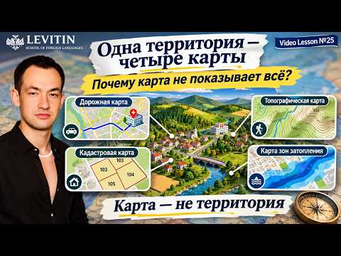
Imagine four people examining the same geographical area.
One needs to reach a hospital. Another wants to walk through hilly terrain. A third needs to identify property boundaries. A fourth is investigating potential flood risks.
Each person may need a different representation of the same place.
What Will You Learn?
This video compares four types of maps:
- Road maps: Roads, connections, and navigation.
- Topographic maps: Elevation, terrain features, and geographical orientation.
- Cadastral maps: Land parcels and property boundaries.
- Flood hazard maps: Areas potentially affected by flooding under specified conditions.
You will discover why a map can be accurate without showing everything, how cartographic choices influence interpretation, and why the information missing from a map can be just as important as the information displayed.
We also examine an important distinction in digital mapping: Terrain mode is not the same as a complete topographic map. Showing relief does not automatically provide all the information required for detailed topographic analysis.
The Central Question
What does this map allow me to understand — and what does it leave out?
Understanding geography means more than identifying places. It means evaluating information, recognizing limitations, and choosing appropriate tools for real-world decisions.
A good map does not need to show absolutely everything. It needs to communicate the information relevant to a particular task while making its important limitations understandable.
Explore the Full Research
Read the extended Russian-language investigation in our Language Thinking Laboratory:
The article explores cartographic generalization, map projections, geographical scale, spatial data, symbols, classification, and critical interpretation in much greater depth.
Related Geography Lessons and Resources
Geography as a Way of Understanding Space
Explore our earlier video lesson, Geography Is the Language of Space.
This lesson introduces geographical thinking beyond memorizing names and locations. It provides a useful foundation for understanding why maps are more than collections of geographical symbols.
A Russian-language version is also available: География — это язык пространства.
Geography Through Another Language
Our article Geography in German — Learn to Understand the World Through Erdkunde-Fachsprache explores the connection between geographical understanding and subject-specific German.
This creates another learning pathway: understanding geographical concepts while developing the language needed to discuss them in an academic environment.
Learn Geography and Academic Subjects Online
At Levitin Language School, we connect language learning with academic understanding and practical problem-solving.
Our individual online lessons can help students develop geographical reasoning, understand maps and spatial information, work with subject-specific terminology, and study academic subjects in the language appropriate to their educational needs.
Lessons are individually organized according to the student’s goals, level, and learning requirements.
Levitin Language School — Learning to understand, not simply memorize.
© Tymur Levitin | Levitin Language School